![]() Geography
Geography![]()
![]() Q. 1. Mention any two main regions of commercial dairy farming. [1/2 + 1/2 = 1]
Q. 1. Mention any two main regions of commercial dairy farming. [1/2 + 1/2 = 1]
Answer: The main regions for dairy farming on a commercial basis in the world are
- The largest is North-Western Europe.
- Canada and North-Eastern USA.
- South-Eastern Australia, New Zealand and Tasmania.
![]() Q. 2. Which inland waterway of the world is most heavily used ?
Q. 2. Which inland waterway of the world is most heavily used ?
Answer: Rhine Waterways.
![]() Q. 3. Name any two towns of India, initially developed as educational centres. [1/2 + 1/2 = 1]
Q. 3. Name any two towns of India, initially developed as educational centres. [1/2 + 1/2 = 1]
Answer: Some towns of India were initially developed as education as their primary function are : Roorkee, Varanasi, Aligarh, Pilani, etc.
![]() Q. 4.Why is West Asia the least developed in rail facilities ? Explain one reason.
Q. 4.Why is West Asia the least developed in rail facilities ? Explain one reason.
Answer: West Asia is the least developed in terms of rail facilities because of vast deserts and sparsely populated regions.
![]() Q. 5. Examine the twin environmental problems that have emerged in the ‘Indira Gandhi Canal Command Area’.
Q. 5. Examine the twin environmental problems that have emerged in the ‘Indira Gandhi Canal Command Area’.
Answer: Due to intensive irrigation and excessive use of water has led to the emergence of problems of water logging and soil salinity and both these have an adverse effect on soil fertility and agricultural productivity.
![]() Q. 6. Classify minerals on the basis of chemical and physical properties. [1/2 + 1/2 = 1]
Q. 6. Classify minerals on the basis of chemical and physical properties. [1/2 + 1/2 = 1]
Answer: Minerals are divided into groups on the basis of chemical and physical properties. These are:
- Metallic and
- Non-Metallic minerals. Examples of metallic minerals are iron, copper, gold, silver and non-metallic minerals are salt, coal, copper, etc.
![]() Q. 7. How can you help in improving the quality of water in your locality ? [1]
Q. 7. How can you help in improving the quality of water in your locality ? [1]
Answer: Quality of water suffers from large scale of pollution almost throughout the country. In the populated locality, we can avoid dumping all waste matter into water and into our rivers.
![]() Q. 8. Study the map given below carefully and answer the Questions that follow : [3]
Q. 8. Study the map given below carefully and answer the Questions that follow : [3]
Answer: The canal shown in map is Suez Canal, constructed in 1869 between Port Said and Port Suez in Egypt.
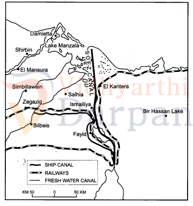
![]() Q. 8.2. Write any four characteristics of this canal.
Q. 8.2. Write any four characteristics of this canal.
Answer: The main characteristics of this canal are:
- It gives Europe a new gateway to the Indian ocean and reduces sea-route distance between Liverpool and Colombo by 6400 km compared to Cape of Good Hope route.
- It is a sea level canal without locks which is 130 km long and 11 to 15 meter deep.
- About 100 ships travel daily and each ship takes around 10-12 hours to cross the canal.
- As the tolls are heavy, some find it cheaper to go by the longer Cape Route whenever the consequent delay is not important.
- A navigable fresh canal also follows from Nile.
![]() Q. 9. Describe any three features of open-cast mining.
Q. 9. Describe any three features of open-cast mining.
Answer: Features of open-cast mining are
- This is the cheapest and easiest method of mining and is used for mining those minerals which occur close to the surface.
- The overhead costs such as a safety precaution and equipment is relatively low.
- The output is both large and rapid.
![]() Q. 10. Study the diagram given below and answer the Questions that follow : [3 × 1 = 3]
Q. 10. Study the diagram given below and answer the Questions that follow : [3 × 1 = 3]
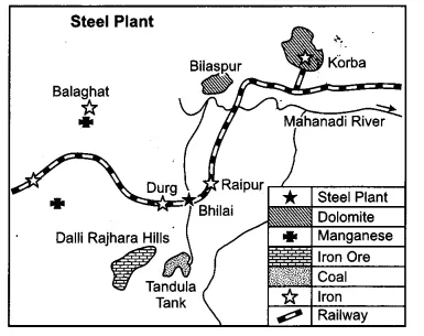
![]() Q. 10.1. Identify and name the steel plant given above. In which state this plant located ?
Q. 10.1. Identify and name the steel plant given above. In which state this plant located ?
Answer: Steel plant is “Bhilai” and located in Chhattisgarh State.
![]() Q. 10.2. Which is the main source of power for this steel plant ? Which rail route provides transport facilities to this plant ?
Q. 10.2. Which is the main source of power for this steel plant ? Which rail route provides transport facilities to this plant ?
Answer: Main power source is “Korba Thermal Power Station”. The rail route connecting to this plant is Kolkata-Mumbai rail route.
![]() Q. 10.3. What are the major sources of Iron ore and water for this steel plant ?
Q. 10.3. What are the major sources of Iron ore and water for this steel plant ?
Answer: Major source of rich Hematite Iron Ore for this plant is “Dalli-Rajhara range” of mines. The water source is “Tandula Tank”.
![]() Q. 11. “There is no consensus on what exactly defines a village or a town.” Analyse the statement by using different criteria.
Q. 11. “There is no consensus on what exactly defines a village or a town.” Analyse the statement by using different criteria.
Answer: We all live in a cluster of houses which can be called as a village or a town. It is widely accepted that settlements can be differentiated in terms of rural (village) and urban (town), but there is no consensus on what exactly defines a village or a town. Although the population size is an important criterion, it is not a universal criteria since many villages in densely populated countries like India and China have population exceeding than some towns of Europe and USA. In certain countries, urban settlements are defined on the economic basis. For example, in India, towns are called urban towns cities when it has 75% of its work force engaged in non-agricultural activities, whereas in some western countries an urban area is if more than 50% of the economically productive population are engaged in non-agricultural pursuits.
![]() Q. 12. “Nature provides opportunities and humans make use of these and slowly nature gets humanised and starts bearing the imprints of human endeavour.” Justify the statement.
Q. 12. “Nature provides opportunities and humans make use of these and slowly nature gets humanised and starts bearing the imprints of human endeavour.” Justify the statement.
Answer: When the human being makes use of opportunities provided by nature, it starts bearing the imprints of human endeavour and this situation is known as humanisation of nature. Human beings interact with their physical environment with the help of technology. Technology indicates the level of cultural development of society.
Knowledge about nature is extremely important to develop technology and advanced technology loosens the shackles of environment on human beings. In the early stages of their interaction with their natural environment humans were greatly influenced by it. They adapted to the dictates of nature. This is so because the level of technology was very low and the stage of human social development was also primitive. They create possibilities with the resources obtained from the environment. The human activities create the cultural landscape. The imprints of human activities are created everywhere; health resorts on highlands, huge urban sprawls, fields, orchards and pastures in plains and rolling hills, ports on the coasts, oceanic routes on the oceanic surface and satellites in space.
![]() Q. 13. “Indiscriminate use of water by increasing population and industrial expansion has led to degradation of the water quality considerably in India.” Explain the values that can help in maintaining the quality of water.
Q. 13. “Indiscriminate use of water by increasing population and industrial expansion has led to degradation of the water quality considerably in India.” Explain the values that can help in maintaining the quality of water.
Answer: Indiscriminate use of water by increasing population and industrial expansion has led to degradation of the quality of water considerably. Values that can help in maintaining the quality of water are:
- Judicious/optimum use of water; controlling population and recycle and reuse of water; Watershed Management and Rainwater Harvesting.
- Haryali is the watershed development started by the government of India for the same reason.
- Industries which are located on the river banks should be monitored for the waste disposals. They should not be throwing the waste in the river.
![]() Q. 14. Mention any four major objectives of the New Industrial Policy, 1991 of India. Describe the role of globalisation in achieving these objectives. [2 + 3 = 5]
Q. 14. Mention any four major objectives of the New Industrial Policy, 1991 of India. Describe the role of globalisation in achieving these objectives. [2 + 3 = 5]
Answer: Major objectives of India’s New Industrial Policy 1991 are as follows:
- The New Industrial Policy, 1991 seeks to liberate the industry from the shackles of licensing system. Maintain a sustained growth in productivity.
- Encourage foreign participation in India’s industrial development.
- Gainful employment and attain international competitiveness.
The process of globalisation includes opening up of world trade, development of advanced means of communication, internationalization of financial markets, growing importance of MNCs, population migrations and increased mobility of persons, goods, capital, data and ideas. It refers to the integration of economies of the world through uninhibited trade and financial flows, as also through mutual exchange of technology and knowledge. It also contains free inter-country movement of labour. This implies opening up the economy to foreign direct investment by providing facilities to foreign companies to invest in different fields of economic activity in India, removing constraints and obstacles to the entry of MNCs, allowing Indian companies to enter into foreign collaborations and also encouraging them to set up joint ventures abroad; carrying out massive import liberalisation programs by switching over from quantitative restrictions to tariffs and import duties, therefore globalisation has been identified with the policy reforms of 1991 in India.
![]() Q. 15. Classify the population of the world on the basis of their residence into two groups. How are they different from each other ? Explain. [1 + 4 = 5]
Q. 15. Classify the population of the world on the basis of their residence into two groups. How are they different from each other ? Explain. [1 + 4 = 5]
Answer: The division of population into rural and urban is based on the residence.
| Rural Population | Urban Population |
| (i) The population living in a village is known as rural population. | The population living in towns and cities is known as urban population. |
| (ii) it supports small size population. | Urban population is engaged in secondary and tertiary activities. |
| (iii) Rural population is mostly engaged in agricultural and other primary occupation. | Urban population is engaged in secondary and tertiary activities. |
| (iv) Share of the rural population is 55% of the whole population of the world. | Share of the urban population is 45% of the whole population of the world. |
![]() Q. 16. How is migration a response to the uneven distribution of opportunities over a space ? Explain the economic consequences of migration in India. [2 + 3 = 5]
Q. 16. How is migration a response to the uneven distribution of opportunities over a space ? Explain the economic consequences of migration in India. [2 + 3 = 5]
Answer: Migration is a response to the uneven distribution of opportunities because of the following reasons:
- In India many people live in rural areas and they migrate to urban areas mainly due to poverty, high population pressure on land, lack of basic infrastructural facilities like health, education, etc. This proves that migration is responsible for the uneven distribution over space.
- People tend to move from a place of low opportunities and less safety to a place which has more opportunities and safe.
Economic Consequences
- People migrating send remittance to their families at home and add to economic prosperity.
- Remittances from international migrants is one of the major sources of foreign exchange. In 2002, India received US $11 billion as remittances from international migrants. Remittances are used for food, repayment of debts, treatment, marriages, children education, agricultural development, construction of houses, etc. Thousands of poor villages of many states works as live blood for economy.
- Punjab, Kerala and Tamil Nadu receive very significant amount from their international migrants. Internal Migrants play an important role in the growth of economy of the source area.
![]() Q. 17. “In modern times international trade is the basis of the world economy.” Support the statement with examples.
Q. 17. “In modern times international trade is the basis of the world economy.” Support the statement with examples.
Answer: Trade is the base of the world economy. The exchange of surplus goods between different countries is called international trade. It is the index of economic development of the country. The countries which export the commodities earn foreign exchange. Developed countries are major trading countries. It also helps to raise the standards of living of the people of developing countries. Some densely populated countries have to import raw materials to meet their demands for their economic and industrial development.
Such countries are Japan, Sri Lanka and other countries. The actual tonnage of goods traded makes up the volume. However, services traded cannot be measured in tonnage. Therefore, the total value of goods and services traded is considered to be the volume of trade. The total volume of world trade has been steadily rising over the past decades. Trade of primary products was dominant in the beginning of the last century. Later manufactured goods gained prominence and currently, though the manufacturing sector commands the bulk of the global trade, service sector which includes travel, transportation and other commercial services have been showing an upward trend.
![]() Q. 18. What was the main aim of the ‘Tribal Sub-Plan’ introduced in 1974 in Bharmour area ? Review its contribution in the development of the Bharmour region. [1 + 4 = 5]
Q. 18. What was the main aim of the ‘Tribal Sub-Plan’ introduced in 1974 in Bharmour area ? Review its contribution in the development of the Bharmour region. [1 + 4 = 5]
Answer: The process of development of tribal area of Bharmaur started in 1970s when Gaddis were included among ‘scheduled tribes’. Under the Fifth Five Year Plan, the tribal sub-plan was introduced in 1974 and Bharmaur was designated as one of the five Integrated Tribal Development Projects (ITDP) in Himachal Pradesh. This area development plan was aimed at improving the quality of life of the Gaddis and narrowing the gap in the level of development between Bharmaur and other areas of Himachal Pradesh. This plan laid, the highest priority on development of transport, communications, agriculture and allied activities, social and community services.
The most significant contribution of tribal sub plan in Bharmaur region is the development of infrastructure in terms of schools, health care facilities, potable water, roads, communications and electricity. But the villages located along the river Ravi in Holi and Khani areas are the main beneficiaries of infrastructural development. The female literacy rate in the region increased from 1.88 per cent in 1971 to 65 per cent in 2011. Traditionally, the Gaddis had subsistence agricultural-cum-pastoral economy having emphasis on food grains and livestock production. But during the last three decades of twentieth century, the cultivation of pulses and other cash crops has increased in Bharmaur region. But the crop cultivation is still done with traditional technology. The declining importance of pastoralism in the economy of the region can be gauged from the fact that at present only about one-tenth of the total households practise transhumance.
![]() Q. 19. Classify trading centres into two categories. How are they different from each other ? Explain. [1 + 4 = 5]
Q. 19. Classify trading centres into two categories. How are they different from each other ? Explain. [1 + 4 = 5]
Answer: Classification of trading center
- Rural Marketing Centres :
- Rural marketing centres cater to nearby settlements.
- These are quasi-urban centres.
- They serve as trading centres of the most rudimentary type.
- Here personal and professional services are not well developed. These form local collecting and distributing centres. Most of these have mandis (wholesale markets) and also retailing areas.
- Urban Marketing Centres :
- Urban marketing centres have more widely specialized urban services.
- They provide ordinary goods and services.
- Urban centres offer manufactured goods or finished products.
- Service of educational institution and professionals such as teachers, lawyers, consultants, physicians, dentists and veterinary doctors are available.
![]() Q. 20. Classify means of communication on the basis of scale and quality into two categories. Explain any two characteristics of each category. [1 + 4 = 5]
Q. 20. Classify means of communication on the basis of scale and quality into two categories. Explain any two characteristics of each category. [1 + 4 = 5]
Answer: Classification of means of communication on the basis of scale and quality : Personal Communication System:
- It is the most effective and advanced one and widely used in urban areas.
- It enables the user to establish direct connect through Email to get access to the world of knowledge and information.
- It is used for e-commerce and carrying out monetary transaction.
- It is a huge central warehouse of data, with detailed information on various items. (Letters, Telephone, Fax, Email, Internet, etc).
Mass Communication System
- Radio broadcasting started in India in 1923 by the Radio Club of Bombay and changed the socio-cultural life of people.
- Television broadcasting emerged as the most.
- Use of satellite and synoptic view of larger area effective audio visual medium for information and for economic and strategic reasons.
(Radio, Television, Cinema, Satellite, Newspaper, Magazine and Books, Seminar and Conference, etc.).
![]() Q. 21. Identify the five geographical features shown on the given political outline map of the world as A, B, C, D and E and write their correct names on the lines marked near them with the help of the following information: [5 × 1 = 5]
Q. 21. Identify the five geographical features shown on the given political outline map of the world as A, B, C, D and E and write their correct names on the lines marked near them with the help of the following information: [5 × 1 = 5]
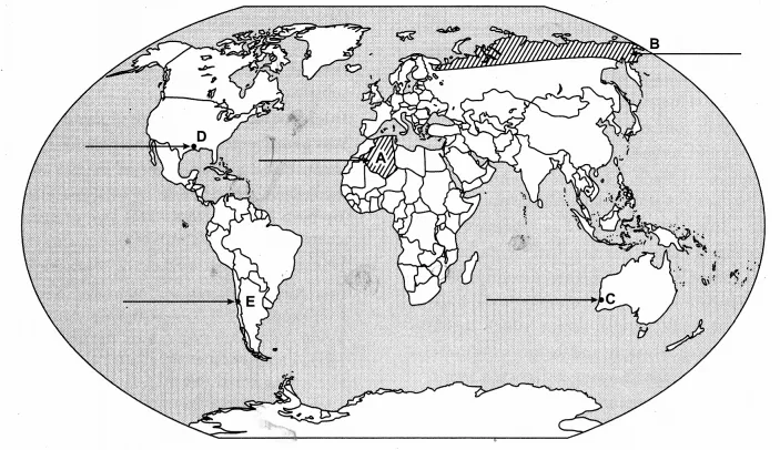
- A large country of africa in terms of area.
- A major area of subsistence gathering.
- The terminal station of a “Transcontinental Railway”.
- A major seaport
- An international airport.
Anwser:

![]() Q. 22. Locate and label the following features with appropriate symbols on the given outline political map of India: [5 × 1 = 5]
Q. 22. Locate and label the following features with appropriate symbols on the given outline political map of India: [5 × 1 = 5]
22.1. The state having the highest density of population according to census 2011.
22.2. The leading rice producing state.
22.3. The software technology park located in Gujarat.
22.4. The major coalfield located in Odisha.
22.5. An international airport located in Tamil Nadu.
Answer: